
Soil Science - The History of Pedology
Regolith is the thin layer of unconsolidated solid material covering most of the earth. Soil is the top layer of regolith, which may contain organic material. It forms the layer between the bedrock, the lithosphere and vegetation, the biosphere. Physical and chemical weathering due to the action of rainwater, temperature or biological activity breaks down rocks to form regolith.
Physical weathering occurs due to temperature changes when water seeps into cracks in the rocks and freezes. As the water freezes, it expands, eventually causing the rocks to break apart. This weathering of exposed rocks normally occurs in mountainous or desert regions.
A chemical process on rocks mainly takes place in damp, warm climates due to water. Acid rain breaks down the rock into a solution during chemical weathering. Acidic water can also cause hydrolysis, producing clays and soluble salts. Oxidation also occurs to breakdown rocks by oxygen and water.
Animals, plants, bacteria, lichens and algae can also break down rocks through biological weathering. Bacteria, lichens and algae produce chemicals that break down rock. Tree roots growing into cracks in the rocks searching for nutrients and water can gradually prize the rocks apart.
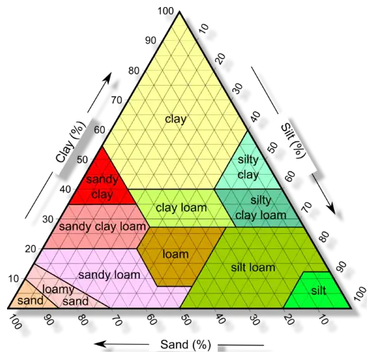
Soil Structures
As these rock fragments are broken into smaller particles by both water in streams and rivers or by wind. These smaller particles consisting of sand, clay, silt, rock fragments, volcanic ash, glacial drift and loam, which is a mixture of sand, clay and silt, form between 50 — 56% of the weight of soil. Along with these inorganic compounds, about 25 — 35% of the soil consists of water. A further 15 — 25% are soil gases, and organic material accounts for a further 5 — 10%. These percentages can however vary enormously.
Soil has been important to farmers for millennia for the rich nutrients it provides for growing crops. It was the main building material from 7000 to 3300 BC, when inhabitants in Mehrgarh in Southern Asia constructed houses made from mud-bricks. Made from loam, mud, sand, and water and originally sun-baked. Improvements to the strength of the bricks came about later, due to firing in a kiln.
The History of Soil Science (Pedology)
Although ancient Greeks such as Plato (428 – 348 B.C.) had recognised the three primary elements of matter as air, earth and fire it was Jan Baptista van Helmont (1580 – 1644) a Belgian Scientist, who performed an experiment of growing a willow weighing 2.27 kg (5.0 lb) in 90.72 kg (200 lb) of dried soil. To prevent any dust entering from the air, iron sheets covered the pot. He only added rainwater to the plant, and after 5 years the plant weighed 76.66 kg (169 lb). He then dried the soil again and found it weighed 90.66 kg (199.87 lb). Since, the wood of the tree had increased to 74.39 kg (164 lb). Jan Baptisa van Helmont concluded only the water had increased the material in the tree. He overlooked the soil loss of 56.7 g (2 oz) and knew nothing of photosynthesis.
A Dutch humanist, philosopher and physician, Hermann Boerhaave (1668 – 1738) was the first to identify the nutrients from soil are essential for plant growth. In his book “Elementa Chemiae” (A Method of Chemistry) published in 1727, Boerhaave indicated that plants “absorb the juices of the earth and then work them up into food”. After Helmont’s early experiment it took different scientists until 1774 when Joseph Priestly (1733 – 1804) published “Experiments and Observations of Different Kinds of Air” in which he identified that plants could restore air that was “injured” by the candle and the mice. Photosynthesis was eventually discovered by Jean Sénébier (1742 – 1809) a Swiss botanist in 1796, when he demonstrated that plants absorb carbon dioxide (CO2) and release oxygen (O2) with the help of sunlight.
The Fathers of Soil Science
Soil Science a modern science, the first scientists were Friedrich Albert Fallou (1794 – 1877) German Scientist who was described as the “The Father of Soil Science”, although it was Vasily Vasilyevich Dokuchaev (1846 – 1903) a Russian geologist and Geographer who is credited with laying the foundations of soil science.
Albert Fallou published “First Principles of Soil Science” in 1857 and “Pedology, or General and Special Soil Science” in 1862. In his 1862 book he describes the nature and aims of soil science and why soil science should be an independent natural science and should be studied. He also discussed the origin of soils, particularly the role of weathering.

Vasily Vasilyevich Dokuchaev developed soil science in Russia and carried out wide geographical investigations of different soil types. Vasily suggested that geographical variations he found could be various factors. These were parented material, geographical factors, climate topographical factors and time available for soil formation to occur. He became curator of the geological collection of St. Petersburg University in 1872. He conducted courses in mineralogy, crystallography and first course anywhere on Quaternary deposits when appointed Privatdozent in geography at the university in 1879.
During this period Konstantin Dimitrievich Glinka (1867 – 1927) a Russian soil scientist was a student of Dokuchaev. He published his work “Die typen der bodenbildung, ihre klassifikation und geographische verbreitung”, (The types of soil formation, their classification and geographical spread) in 1914. In 1927 Glinka gave a lecture at the first international congress of soil science. During his lecture, he acknowledged the important work of Fallou, but appeared to downplay Falluo’s contribution in favour of Dokuchaev. He was Director of the Agricultural College of Leningrad and Experimental Station and in 1927 the first Director of the Dokuchaev Soil Science Institute. In 1906 Glinka published the first world soil map.
The Soil Survey of Missouri
Dr. Curtis Fletcher Marbut (1863 – 1935) a United States soil scientist contributed to advances in soil classification in agriculture and geography. He was a lecturer at the University of Missouri, teaching geology and mineralogy. He served as a director of the Soil Survey of Missouri and published papers on “Physical Features of Missouri” and an article on “The Geographic Development of Crowley’s Ridge, Missouri-Arkansas”.
The standard conceptual model for pedology
Hans Jenny (1899 – 1992) was a Swiss Pedologist and Soil Scientist. He set down the generic mathematical relationship that connects the observed properties of soil with the independent factors that determine the process of soil formation
Where:
S = soil formation
cl = climate
o = organisms
r = relief
p = parent material
t = time
The open ellipsis is to indicate that there might be more variables in the function
After an appointment at the University of Missouri for 7 years, in 1936 he joined the faculty at Berkeley.
Appointed Associate Professor of soil chemistry and morphology in 1936. His promotion to Professor occurred in 1940. In 1949, he was President of the Soil Science Society of America. In his “The Soil Resource, Origin and Behaviour” in 1980 he redefined the soil forming factors as state variables, extending the effects of ecosystem properties.
Another international soil scientist was Guy Donald Smith (1907 – 1981) was from Atlantic City, Iowa. After receiving his Master’s degree in 1934 he then published the first of many publications, Missouri Agricultural Experiment Station Research Bulletin 210 was his study of clay pans and translocation of clay soils which brought him recognition as a pedologist. His study of pedologic interpretations of the properties and distribution of Illinois loess was published in 1942 and established him as a soil scientist. In 1952, he was Director of Soil Survey Investigations in the U.S. Department of Agriculture. He was awarded a Doctorate of Science in 1968 by the University of Ghent.
Continuing Research into Soil Science
Research in soil science is still continuing. In Scotland, data and information about Scotland’s soils are available to anyone who needs it. Provided by a partnership that includes The James Hutton Institute, NatureScot, Forestry and Land Scotland and The Scottish Government. The website is Scotland’s Soils part of Scotland’s environment, and it provides the latest news about soil as well as a National soil map of Scotland, Soil risk maps, Carbon and peatland 2016, Land capability for agriculture and Resources for land managers and developers.
Another resource available for the whole of the UK is the UK Soil Observatory. This website is a NERC funded project and is a consortium of partners including the Centre for Ecology & Hydrology, British Geological Survey, James Hutton Institute, Cranfield University, Rothamsted Research, Agri-food and Bioscience Institute, Forest Research, Forestry Commission and British Society of Soil Science. Similar to the Scottish site, the Soil Observatory provides soil related news, events, data releases and research. The website also includes maps, a monitoring programme, details of observatories and long-term monitoring sites, mobile apps and other tools, resources and publications.

The European Perspective
The European Commission’s Joint Research Centre has set up the European Soil Data Centre. The Centre provides an online Soil Atlas of Europe. The atlas is the result of a collective effort by more than 40 National soil surveys and soil science institutions cooperating across Europe within the European Soil Bureau Network.
Soil science is important for land managers, farmers, forestry managers and flood management. It is also significant for the construction and building industry. In order to build new developments, engineers need to determine the condition of the ground. They can do this by accessing the soil research resources detailed above and by carrying out ground investigations. This may be to determine the soil profile, identify natural faults or made up ground that might affect the mechanical properties of the soil. To prevent flooding and design drainage systems, it is critical that the depth of the water table is known and the permeability of the soil.
